Peace in South Caucasus; Too far, too close + map
| Perhaps the most important dispute that has been the root of many tensions between Armenia and Azerbaijan so far, and it seems that if it is not resolved, it could be the starting point of military conflicts in the South Caucasus, is the determination of the basis of geographical divisions and the determination of border boundaries between the two countries. |
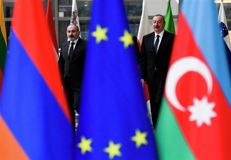
According to the international group Tasnim news agency, a few days ago Nikol Pashinyan in an intra-party briefing He explained the issues of dispute and tension between Armenia and the Republic of Azerbaijan.
The issue that was clearly evident in this meeting and in the speeches of the President of Armenia is the existence of serious and deep legal and political differences between the two countries. In the last meeting that the two presidents had in St. Petersburg, Russia, on the sidelines of the Eurasian Economic Summit, there were speculations about the gradual resolution of differences between Yerevan and Baku. In the way that Kremlin spokesman Peskov spoke about the readiness of the two countries to move towards peace at the end of the St. Petersburg meeting. The South Caucasus cannot be achieved so easily.
Some of the disputes that Pashinian mentioned in the above meeting have a legal aspect and some have a political aspect, which seems to be related to the conditions governing the political, intellectual and media environment. Two countries and even countries like Turkey, Russia and Iran, the resolution of these disputes depends on the will of all interested countries.
Legal disputes
The most important legal dispute, which has been the root of many tensions between the two countries until now, and it seems that if it is not resolved, it could be the starting point of military conflicts in the South Caucasus region, determining the basis of Geographical divisions and demarcation of borders between two countries.
After the collapse of the Soviet Union and the declaration of independence of Azerbaijan and Armenia in 1991, the political conflicts between the two countries, which had been formed for years over the ownership of Nagorno-Karabakh, 1988 entered the military phase and continued until the middle of 1994.
In 1991, the two countries signed the Almaty Declaration to respect each other’s territorial integrity based on the last Soviet-era maps. Also, the two countries signed a peace plan with the mediation of the heads of Russia, the United States, France, and the Organization for Security and Cooperation in Europe in the form of the Minsk Group, which was based on the recognition of the borders of the two countries on the maps of the Soviet Union.
The above roles are the basis of action and peace between the two countries was established in 1994 until the start of the second Karabakh war in 2020, after which, based on the re-conflict of the two countries, the procedure of Azerbaijan in identifying the border boundaries was completely different.
But now and Currently, after the Third Karabakh War and the recapture of the disputed areas, the political conditions in the South Caucasus region have changed as a whole.
In the way that the Armenian government, in the proposed peace package it presented, requested the recognition of territorial integrity. The two countries are based on the maps available in the Ministry of Foreign Affairs and the Joint Staff of the Russian Army from 1975.
In these maps, the official area of Azerbaijan is 86,600 square kilometers and the area of Armenia is 29,743 square kilometers.
In the conflict of Nagorno-Karabakh or Artsakh, the Armenian government recognized the sovereignty of the Republic of Azerbaijan over this region on the basis of this argument and referring to the above maps, and did not intervene in the third Karabakh war that lasted for a day. But the problem starts from the point where the government of Baku does not accept and does not recognize the basis of the border threats based on the 1975 maps.
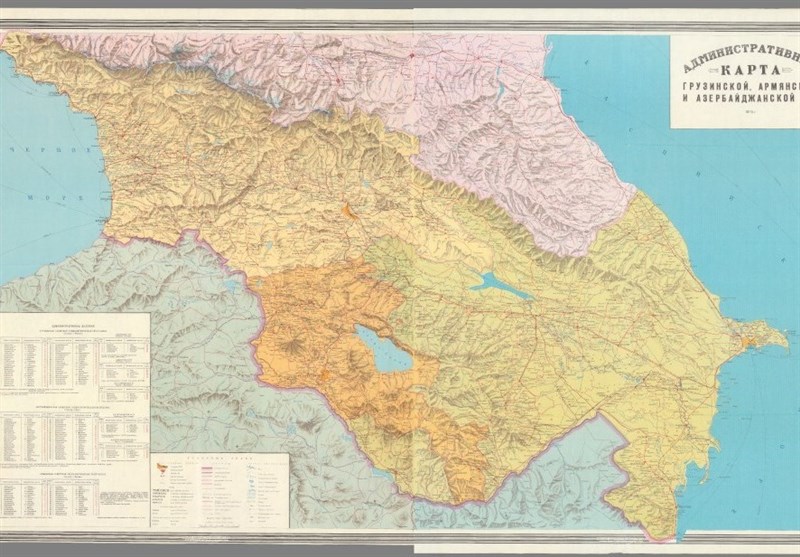
The map of the South Caucasus in the Joint Staff of the Russian Army in 1975 and The case cited by the Armenian government regarding border delimitation
Elham Alif claims that any border delimitation between the two countries based on the maps of 1975 is not acceptable, and to reach lasting peace in the region, the maps of 1920 should be used. which is related to the 23-month period (1918-1920) of the formation of the government of the “Azerbaijan Democratic Republic”, to be the basis of the demarcation of the border between the two countries, but this request of the Azeris was not accepted by the Armenian authorities.
Meanwhile, “Mohammed Amin Rasulzadeh”, who headed the Equality Party during the “Federal Democratic Republic of the South Caucasus”, claimed an independent government after the dissolution of this republic. In the declaration map of his new government called “Democratic Republic of Azerbaijan”, Rasulzadeh declared all the regions of the current Republic of Azerbaijan, Nakhchivan and the region of Zangilan (Zangzor) or the current Sionik as part of the territory of his government.
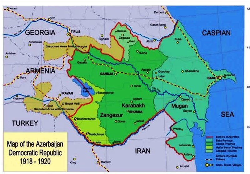
Republic Map Democratic Azerbaijan from 1918 to 1920
The government of Rasulzadeh did not last more than 23 months with the Soviet political structures taking power and the invasion of the Red Army. After the collapse of the short-term government of the Azerbaijan Democratic Republic and the replacement of the Soviet structures and the formation of the Azerbaijan Soviet Socialist Republic, the maps and territorial divisions in the South Caucasus were reformulated in a way that the Stepanakert region, or the mountainous Karabagh, was located within the borders of the Azerbaijan Soviet Socialist Republic. and the administration of the Nakhchivan Autonomous Republic was entrusted to Azerbaijan, but the Sionik region, or Zangzor, was again under the rule of Armenia.
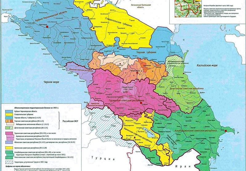
The map of the Soviet Union after overthrowing the government of the self-proclaimed Democratic Republic of Azerbaijan in 1921
But currently the Baku government wants territorial divisions based on the alleged plans of the Democratic Republic of Azerbaijan. This is despite the fact that in the same period of time, the aforementioned government was not at all comprehensive in the way that Baku and its neighboring provinces were under the control of the Bolsheviks and representatives of Russia. Also, the nationalistic and Panterkist thinking, the current government of Azerbaijan considers its sovereignty to be the continuation of the government of the Democratic Republic of Azerbaijan and on this basis has claimed the southern regions of Armenia and Sivnik Province of this country.
After 2020 and the Second Karabakh War, This demand was raised under the banner of obtaining a communication corridor between the main land of the Republic of Azerbaijan and the autonomous region of Nakhchivan, or the Zangzor Corridor, which has been accompanied by strong opposition from Armenia and Iran. This time, Alif went further and requested the recapture of these territories by using the maps of 1920 and changing the name of the southern regions of Armenia to West Azerbaijan. Achieving lasting peace in the South Caucasus has been rejected by Baku, and this country has announced that it is willing to accept peace only if it accepts the terms proposed to Sivnik. Azerbaijan’s demands in the current situation are beyond the creation of the Zangzor Corridor, and this country wants to annex the southern lands of Armenia to the lands of Azerbaijan with a developmental perspective.
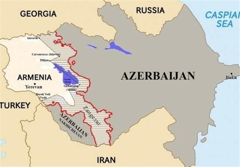
Salted parts of the territories claimed by the government of the Republic of Azerbaijan in the territories Armenia
According to the agreements of Golestan in 1813 and the Treaty of Turkmenchai in 1828, it was separated from Iran.
According to the divisions of Tsarist Russia, the South Caucasus region, i.e. the upper reaches of the Aras River, is divided into three provinces, with The names of Baku province, Yerevan province and “Elizavetpol” province or military region, most of Zangzor or Sivnik region is located in this province.
At the end of World War I and the collapse of the Tsarist Russian Empire in 1917 There are changes and self-proclaimed governments are formed, one of which was the Democratic Republic of Azerbaijan. This is the first time that the name Azerbaijan is used for the lands north of the Aras River, which is facing strong protests from the Iranian government.
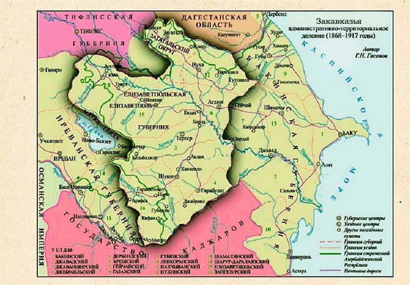
Map of the South Caucasus between 1868 and 1917 in the period of Tsarist Russia There is no such region called Azerbaijan
But the problem does not end here, the Azeris claim to own their ancient lands. By looking at the history and historical maps available in scientific centers, this claim can be easily investigated.
According to the documents in the archive of Russian sources, in the agreements of Turkmenchai and Golestan, the tsarist government of Russia took areas from Iran. separated According to these agreements, as a result of the two wars between Russia and Iran, the lands of the northern provinces of Iran were separated from Iran and became a part of the Russian territory. Thus, the former Iranian khanates and sultanates became the provinces of Baku and Quba. , Sheki, Shirvan, Karabagh and Lankaran, as well as the military districts of Elizavetpol and Jarbalaken.
In the second half of the 19th century, the provinces and regions of the East Transcaucasia changed in terms of the structure of political divisions, and the provinces of Baku, Shamakhi and Lankaran became centers in Baku province. The territory of the former Khanate of Ganja, Karabagh and Sheki, after joining Russia, first became a province and in 1867, as a county, it became part of Elizavetpol Province.
As we see in the years of the Russian Empire There is no tsarist region called Azerbaijan and originally there were 2 large provinces (Baku and Yerevan) and 1 military district (Elizavetpol) in the South Caucasus.
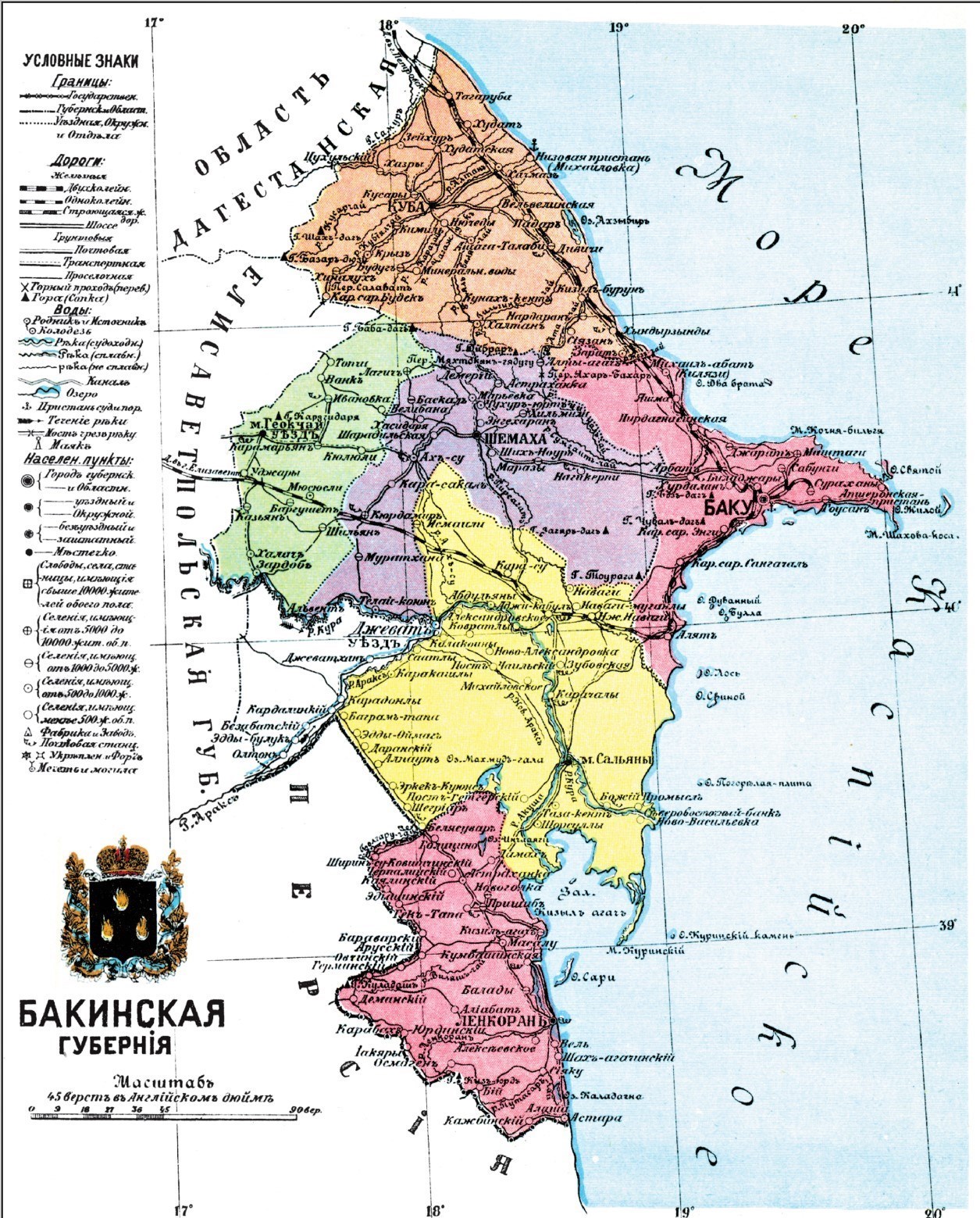
Map of Baku Province during the Tsarist Russia
However, regarding Armenia, it should be said that in the 15th century, that is, when its historical territories fell into the hands of the governments of Iran and the Ottoman Turks, it no longer existed as a state and political structure.
>
But in the 19th century, with the help of Russia, Armenia reappeared on the world map. Therefore, as a result of the Russo-Persian wars of 1826-1828 (Treaty of Turkmenchai), the Khanate of Yerevan and Nakhchivan were annexed to Russia, and the tsarist government turned these areas into Armenian territories again.
However , the Armenian population in the reconstructed Armenia was very small at the beginning of the 19th century, because many of them were scattered throughout the territory of the Ottoman Empire, Iran and other regions north of the Aras River (Aran and Shirvan).
Only then After the war between Russia and Turkey in 1877-1878, the Russian authorities moved the Armenians from the Ottoman Empire (West Armenia Province) to Yerevan Province and settled them. Also, as a result of the Russian-Turkish war in 1878, the Sinjag lands of Kars and Childir were annexed to Russia, which eventually became the Kars region. Therefore, in the period from 1878 to 1917, 2 administrative-territorial units with There was a predominantly Armenian population in Transcaucasia – Yerevan province and Kars region. As we can see, in the years of Tsarist Russia, Transcaucasia consisted of 9 independent administrative-territorial units, which included 5 provinces, 2 There are two military districts. Transcaucasia or the South Caucasus during the Soviet period has identified the main modern administrative plan and its current modern borders.
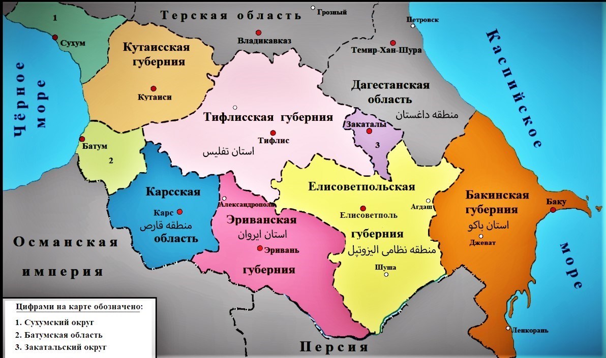
Transcaucasia map between 1883 and 1917
The second legal problem
The second legal problem that has challenged the achievement of peace between the two countries is evacuation The lands are under ownership. This means that based on the proposed peace package of Armenia, which is based on the acceptance of territorial integrity according to the maps of 1975, both countries should evacuate the areas that they currently own and govern, which are called foreign areas in international law, and in
On this basis and based on the same maps (1975 maps), the Armenian government should hand over three areas in Tavush village bordering Georgia and Tigranashen region bordering Nakhchivan to Azerbaijan. and also reciprocally, according to the latest claims of Armenian Prime Minister Pashinyan, the government of Baku should evacuate 32 regions or villages and hand them over to the Armenian government. Of course, the Alif government wants its four outlying areas in Armenia, but regarding the outlying areas of Armenia, based on the same previous claim, referring to the maps of 1920, it has no will to evacuate and hand over the areas.
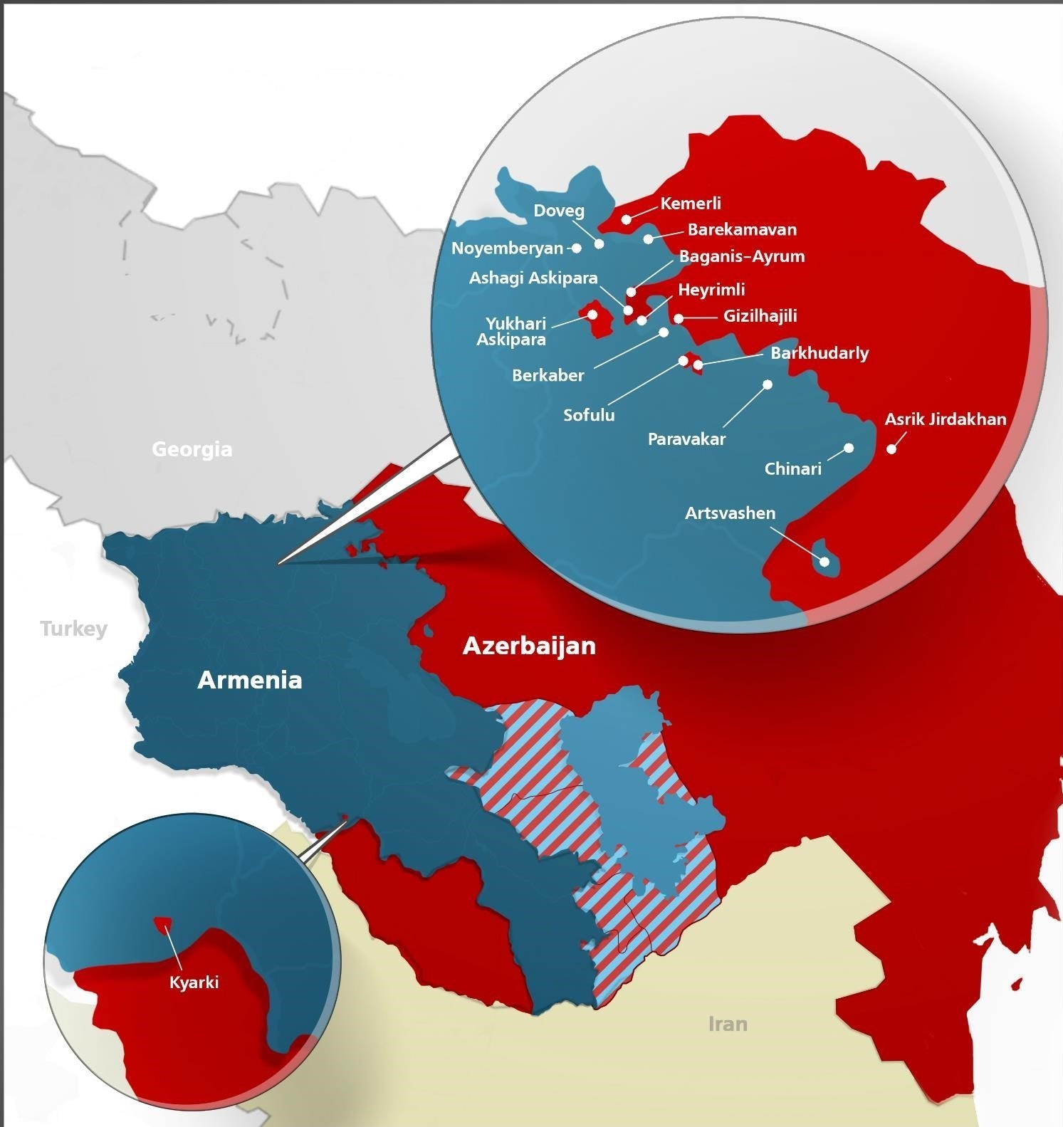
Map of disputed areas and The background of the two countries
In the second part of this note, the political obstacles on the way to peace between the Republic of Armenia and the Republic of Azerbaijan will be discussed.
Author Mehdi Saif Tabrizi, a researcher in the field of Russia and the Caucasus
end of message/
| Publisher | Tasnim News |
|